Monday, October 29, 2012

THE SANDY SAGA - Part 1


We continue…


~ ~ Monday, October 29, 2012 ~ ~

12:00pm – It’s windy. It’s rainy. We experienced more intense precip here earlier in the day, but I definitely wouldn’t want to go outside right now without a raincoat. I found the website for this weather station (Ron Gelaro's) close to my apartment; in the last observation cycle (obs appear to be posted about every 15 minutes), winds were sustained at 11mph with gusts of 21mph. Looking out the window now, I wouldn’t be surprised if those numbers have increased. The center of Sandy is now off of the coasts of New Jersey, Delaware, and Maryland. At the last advisory, Sandy was still a Category 1 hurricane, with sustained winds of 90mph and a central pressure of 943mb. In other words, it actually intensified over night. This storm truly is something like we’ve never seen before.

1:00pm – Hourly updates again! Woohoo!! It’s still windy. It’s still rainy. I still hear the wind chimes. I’m actually amazed that whichever neighbor it is who has the wind chimes has not bothered to take them down and bring them inside. I’m also amazed that other neighbors have left out their potted plants and furniture. Really, people? Really? The wind has begun to literally howl at sporadic intervals. Just now, in fact, it knocked at my door. The latest obs from the weather station down the road? Winds sustained at 18mph, with gusts upwards of 30mph. Sandy is announcing its (or her) presence. (Just after I typed that, there was a rather intense gust that made the whole place pop and creak.)

2:00pm - Things have not gotten better, but they’ve also not gotten terribly worse. The latest obs (it’s actually about 2:30 as I write this, but the 2:00pm obs were not much different) have the winds sustained at 20mph and gusting to 28mph. My power has flickered a bit. Power outages are increasing in the DC/Baltimore area, but thankfully there are few so far in my specific region.

3:00pm – Jinkies! It’s still rather rainy and windy here in my corner of the world. Latest obs down the road: 17mph sustained winds with 25mph gusts. The parking lot in my neighborhood is starting to become a lake down by the mailbox. The wind isn’t great enough to prevent walking outside, but with the rain and temperatures below 50 F, it is cold. In the meantime, Sandy has accelerated and is now moving towards southern New Jersey at about 30mph, faster than anticipated. In a sense, this is a good thing… if the storm moves quickly, it won’t have as much time to cause problems for people in affected areas.

4:00pm – Aren’t these updates boring and redundant?! It’s always “more of the same, more of the same…” Like suddenly *poof!* the weather magic is going to happen and things will get suddenly worse or suddenly better. No, that’s usually not how weather works. Unless, of course, you know it’s going to rain and you decide to go for a short walk before the downpour arrives, only you don’t bring and umbrella and you can see the curtain of rain crossing the street just as you’re re-entering the grounds of your apartment complex, and no matter how fast you run, you can’t escape the torrent of precipitation that is intent on suddenly crashing down upon you and soaking you to your skin in 5 seconds flat. (That’s totally never happened to me. NEVER.) In those instances, weather will change rather suddenly. But most of the time, it won’t. Anywho, standard update: 20mph sustained winds down the road (caveat: provided these observations are accurate) and 33 mph gusts. The howling is becoming more frequent, but SO FAR power is still on here (*knock on wood*), but some areas in the vicinity have not been so lucky. And to think, the worst isn’t even here yet!

I’ve been having fun looking at this site’s archived obs for the past 24 hours. The pressure has fallen steadily, and wind and rain have steadily increased. The wind gusts have gone from about 10mph around midnight to nearly 40mph now. And the area’s gotten 2.86” of rain so far today. Gee, I can’t help but think that number will increase….

What?! No pictures?! Sorry, but you know what a windy, rainy scene looks like in a snap shot? That’s right, exactly the same as it looks any other time, except maybe slightly less contorted, but hey, the winds aren’t THAT strong yet…

5:00pm – 23mph sustained winds. 46mph gusts. The place is creaking. The door knocker is knocking. Oooooooooh boy!

If I blow away, know that I love you all.

Sunday, October 28, 2012

Still waiting...


The updates continue. (I said they would!) All in all, it was a rather uneventful day. Though we did start to see the effects of Sandy, nothing prevented me from heading out to go pick up more supplies, and some stuff I really didn't need to buy (like Republic of Tea Pumpkin Spice Black Tea tea bags. Do I need more tea? Will I be able to brew it in the event that my power goes out? No! It was on sale... I am so weak. So weak!)


~ ~ Sunday, October 28, 2012 ~ ~

5:00pm – Well, it’s a bit windier now. And it’s raining. Not a lot… more of a steady drizzle (there is still a band of heavy precip to my east… still over that same area. It’s been there since at least 11am. That is almost definitely a problem for people in that area). But still, water’s falling from the sky- which itself is looking a bit more ominous:


At the grocery store, some shelves are becoming empty. The bread has been picked over, peanut butter has been scooped up, and matches and batteries are virtually gone. The butterscotch chips, however, were plentiful.

7:00pm – Steady winds, but not insanely windy. More drizzle.

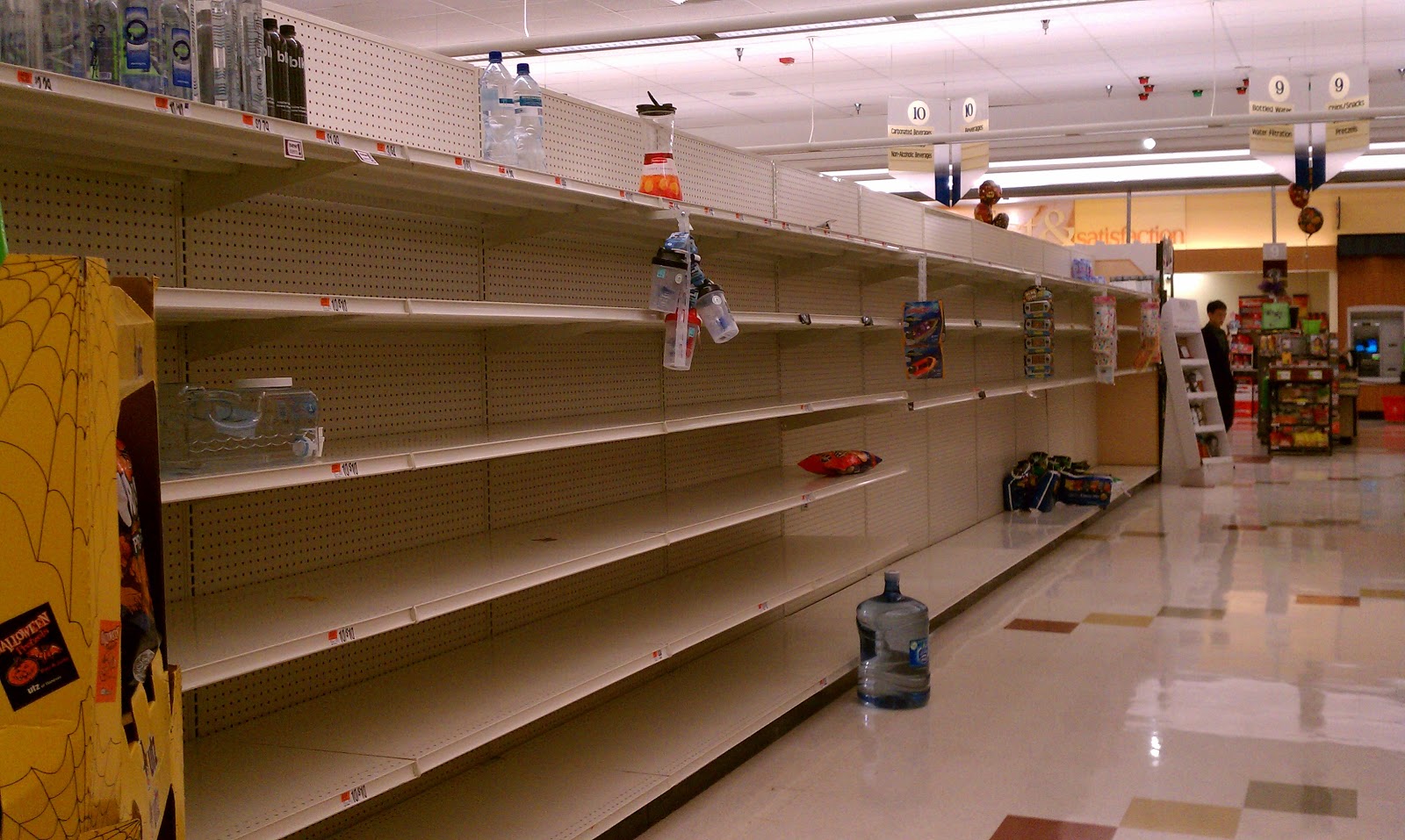
9:00pm - Dark. This is summer no more. Oddly enough, it’s really not that windy. The precip, however, has increased from a drizzle to a steady light rain. I head back to the grocery store for some last minute non-perishables. Apple sauce, crackers… The water aisle is almost completely bare:


I guess it’s good that some people appear to be taking this seriously. Enough that my work is closed tomorrow. I wouldn’t even be allowed on to the grounds if I wanted to go in! But in all honesty, I wasn't about ready to drive the 25 miles each way to and from work in 30+ mph sustained winds. My car has a low-ish center of gravity, but no, sorry, not going to happen.

11:00pm - Still dark. (Imagine that!) The wind is still relatively light, with the occasional stronger gust. The rain has increased. It’s not a downpour in any sense of the word, but definitely a step up from a light rain. I can hear it over my television. Not deafening, but there. I can still hear flights going in and out of Baltimore Washington International Airport. Biscotti is finished. Sandy has moved north, and it's center is now off the coasts of North Carolina and Virginia. Her appearance on infrared reminds me of a nautilus. 

Pre-bedtime (almost 1:00am on Monday) - The wind chimes are chiming again. The rain still rains. The gusts are getting stronger. More in the morning, when the fun REALLY starts.


I had to force myself not to eat more biscotti....

Waiting waiting...

As I promised a friend that I'd blog updates before/during/after the storm, I've been keeping track of the goings on here in my little spot on the East Coast. Ok, so technically I'm not ON the East Coast. I'm actually about 20 miles west of Chesapeake Bay, 75 miles west of Delaware Bay, and about 100 miles west of the Atlantic coastline. But regardless, my region's supposed to get a lot of wind, and a lot of rain. So, I agreed to document what's happening:

~ ~ Sunday, October 28, 2012 ~ ~


12:11am - I look outside the window and find the tree outside the window blowing ever so slightly. 

12:12am- It stops and starts again for a moment.

1:55am - Thus far in my life, I’ve successfully managed to make mincemeat out of calculus exams, I’ve gotten through Swann’s Way and started the rest of Proust’s In Search of Lost Time, I’ve survived Dr. Sun’s Synoptic Scale Dynamics class, I’ve learned how to stand on my head, and I’ve taught myself how to tie my shoes. I still, however, have not been able to figure out how to reliably get myself to bed before 1am. This is a problem. I looked out my window again as I was crawling into bed and saw itty bitty bits of rain clinging to the glass.

9:25am - I don’t like getting up this late, but I like sleeping more. It’s dry outside. Just like last night, it’s mostly calm, but every once and a while I can see the leaves and branches on the trees sway sporadically.

11:00am - Bullocks to this writing down observations at random times stuff. I’m a scientist by training. I’ll write down my observations at hourly intervals! If something super exciting happens, I’ll make exceptions. It goes without saying that the sky is cloudy. Winds are light, but mild gusts occur occasionally. I can hear the neighbor’s wind chimes going constantly. A band of heavy rain is off to the east, and is very slowly moving its way west. Sandy is still a Category 1 hurricane, and its center is still off the coast of the Carolinas. The most recent NHC advisory has no expected changes to Sandy’s forecast track, and states that it is still possible for Sandy to intensify some as it remains over warm water. The storm is, however, expected to become extratropical (tropical cyclones are warm core systems - heat engines in a sense – that occur in areas of relatively homogenous temperature and get their energy from the heat released when clouds and rain form; extratropical cyclones are cold core systems that draw their energy from the instability created by meridional temperature gradients). 

** SCIENCE ALERT ** Of key importance in forecasting Sandy’s track and where it will ultimately make landfall are two other systems: a center of high pressure off to the north/northeast, and a cold front to the west. The high pressure system to the north/northeast is essentially acting like a wall or barrier, blocking any weather systems heading in its general direction. Meanwhile, the frontal system to the west is associated with a trough, or dip, in the jet stream. Normally this type of feature would push Sandy out to sea as it moves east, but this particular trough is negatively tilted (or tilted to the east; typically a trough would be a bump in the flow: winds coming from the west would dip down and head to the southeast before leveling out and heading back northeast. In a negatively tilted trough, westerly winds will dip southeast, level out, and be forced back to the north and west before they’re able to turn east again). As this trough continued to move east, it will meet up with Sandy and the negative tilt in its winds will pull Sandy to the west/northwest, out of the ocean and towards New England and the Mid Atlantic Coast. (Image from UCAR)


12:00pm - No new news. Still a rain band off to the east. This whole storm thing can really throw you for a loop. It’s not here yet, but you KNOW it’s coming.

1:00pm - See above. I’ve been looking at this on radar for the past… who knows how long: (Radar graphic from UCAR)


Arrrrrrrrggghhhh!! The sky is grey. The neighbor is bringing in copious amounts of firewood. I think I’ll make use of the remaining eggs and butter in my fridge and make biscotti. With butterscotch chips. Also, at this time, I can still hear the flights coming in and out of the Baltimore Washington International Airport.

2:00pm - More of the same. That band of rain I keep on talking about? It still hasn’t moved. *Cue music* Floooooooding on the other side of the baaaaaaaaaayyyyy…

3:00pm - Derr derr derrrr. It appears North Carolina is getting hammered, but it’s more of the same here. Perhaps I shall go to two hourly updates. But while it is not very windy and not rainy, I think I shall pop on out and go get myself those butterscotch chips…

Saturday, October 27, 2012

Frankenstorm's Monster


Hello again, Blog World.

As this collection of bits and bytes accessible to any and all with an internet connection will attest, in the past I have traveled many many miles in order to experience, study, and observe inclement weather. After one particularly awful birthday, I left my last weather venture (ROTATE 2012) early in order to relocate myself to the East Coast of the United States of America. And now, wouldn't you know it, it appears that the inclement weather may be coming to me.

That's right folks, on October 22, 2012, the eighteenth tropical depression of the season was christened "Sandy" and began to stroll north, stepping on Jamaica, Cuba, and Haiti before setting its sights on the Bahamas and the open ocean. It churned and churned and churned past Florida and as I type, its center is off the coast of the Carolinas as it undergoes a freakish transformation from tropical system to extratropical monster. Indeed, Sandy’s moniker “Frankenstorm” has nothing (ok, almost nothing) to do with the fact that the storm is occurring close to Halloween, nor does it have anything to do with the fact that you can see the heavily scarred and disfigured visage of a madman’s science experiment in Sandy’s satellite imagery if you squint your eyes and look close enough.  Oh no, the name “Frankenstorm” first appeared in an HPC discussion on October 25th, where forecaster Cisco mentioned that it would be a “GHOULISH NICKNAME.” (NOAA forecast discussions are generally all in caps. They also make heavy use of acronyms, which can make them difficult to read.) The fabulous FunnelFiasco has archived the discussion in question here. As you can see, Sandy was dubbed “Frankenstorm” because it was expected to become some freakish conglomeration of different storm parts, melded together to form a monster storm, like the reanimated body of some cold corpse; unnatural and shunned by man because they cannot understand its gargantuan stature or gruesome appearance.

(Literature aside: Contrary to popular belief, Frankenstein was not the ghoulish monster we’ve come to know and love with pale, pasty skin and battery terminals embedded into its suture laced neck. Frankenstein was instead the man that created the monster of which I speak; some mad scientist obsessed with the idea of bringing a body back from the dead. He never gave the monster a name, nor were we ever told what exactly the monster looked like. Instead, we were shown an initially kind and articulate creature who only wished to be loved and accepted, but who was despised and turned away by all, even his own creator, because of his hideous appearance. The trauma of constant rejection caused him to become slightly sociopathic, and he went on a crusade to make his creator suffer as much as humanly possible by destroying all of the people Frankenstein held dear. And to think, all the monster really wanted was to be loved!)

I look out the window now and it is calm. This won’t, however, last for long. I expect the rain to start some time while I sleep tonight, and tomorrow things will likely get windy. I plan to blog this experience, and if the power happens to go out while Sandy passes by, I’ve promised my friend Derrick (atmospheric science grad student and occasional contributor to weather stories at Lafayette, Indiana’s Journal and Courier) that I will continue my blogging in an old school manner: with ink wells and a glass pen.

(I’d also like to say at this time that I don’t think I’ll be driving to Kansas to escape the storm, and that I seriously doubt that Kansas has cupcakes that can rival the likes of which I have found at my favorite cupcake shop here.)


Sandy and the Great-Big-Late-October-Cold-Bringer, as seen by the NASA GOES-13 satellite on Friday, October 26, 2012. I can't think about this storm without getting the Evelyn Evelyn song, "Sandy Fishnets," stuck in my head. Image source - http://www.flickr.com/photos/gsfc/8125127055/in/photostream


Even though the heart of Sandy is still several hundreds of miles away off the coast of the Carolinas, it's cloud shield was still overhead today. Standing facing the horizon are three sentinels of that vast and "advanced" network of cables and wires that brings power forth from the depths of the earth and eons past and delivers it to your home so that you may pop fresh popcorn for your weekly movie nights. In the distance, Sandy whispers a grim promise to these sentinels that is carried on the wind to their innocent, metaphorical ears. "I'll get you," she says. "Beware, for I'm coming, and by the time I am gone, none of you shall stand!"

Saturday, May 26, 2012

End Of My Season

May 25, 2012. The day started at midnight with off key singing and stories and camaraderie. And that was beautiful.

After sunrise, the armada woke up in Lawrence, Kansas to thoughts of pushing a little farther west. Convection wasn’t necessarily a given, but if clouds were to break the cap, the ingredients were there for them to become supercellular. And well, they kind of did:


Now, those are the kind of storms that CSWR likes to see. After several days of largely uneventful weather, ROTATE was able to observe and collect data on a few tornadoes in western Kansas. Unfortunately, a couple of the vehicles found themselves a little too close to one of these tornadoes and sustained some damage to themselves and to their instruments. Thankfully, however, all occupants of those vehicles, as well as all other members of the CSWR team and a woman whose home was destroyed in the vicinity, made it through the storm with little to no harm. Kind of puts a whole new spin on intercepting a tornado…


In all that exists in the world, storm chasing is but of its own little microcosm. Unfortunately, life does not stop for the chase. I had to depart from the project on the morning of May 25, 2012 to make my way back home and back to real life. I’d like to give a big thanks to all of the CSWR crew (past and present) for being such great individuals. It is hard enough as it is to live out of a suitcase for weeks at a time while constantly worrying about whether you are eating enough greens. It would be nearly impossible were it not for the amazing people you get to share that time with. Miss you all, and hope to see you soon.

PS- You’re welcome, Josh.

We are ROTATE2012. Well, half of it anyway. In no order: Mareike, Maryam, 
Chris, Ronan, Taylor, Herb, Melissa, Lindsay, Rutger, Eric (Not Tim), Alycia,
Rachel,  Brian, Eddie, and erin. Photo by Melissa Guzinski. 

Thursday, May 24, 2012

Status Status!

 Believe it or not, it’s actually been a rather busy week for CSWR. Since the last post, the armada has gone from Kansas to South Dakota to North Dakota to South Dakota to Iowa and Nebraska. Given that two of these three days have been active mission days, mornings have been rather early, sleep has been rather limited, and breakfast has been rather elusive. A chase in North Dakota yielded little other than some views of a picturesque landscape and the sighting of a single, weak, brief tornado. After cutting our loses there, we headed down to Nebraska, where the chase provided us with some weak gustnadoes and some ominous looking scud (stratocumulus under deck) clouds. Our DOWs and mesonets were able to collect some data on the storms we did see, but the perfect storm with the perfect tornado still remains to be seen.

Sccccccccccccccud!

Since, however, it would be gloomy and depressing to leave this blog post on that note, I figured now would be the perfect time to explain a little bit about how we, as chasers and research meteorologists, live while we’re out here on these field projects. (Apologies if I've made a post like this before... it was late and I was exhausted...)

Being on a project like VORTEX or ROTATE is certainly a unique experience. A CSWR field scientist essentially spends their time on a project living out of a truck and a suitcase. The typical day involves getting up early enough to be packed (hopefully showered and fed) and ready to leave by 7-10am Central Daylight Time. It doesn’t matter if the town we happen to be staying in at that moment is on Mountain Time; since tornado alley is mostly in the Central Time Zone, all of our operations simply take place going by central time (even though all of our observations are recorded in UTC).

After packing up all of our things and our vehicles, the armada typically leaves and heads to or towards some pre-determined target that was identified either that morning or the night before based upon observations and where the weather models are indicating that conditions might be ripe for severe weather. On some days, this initial target can be sixty or seventy miles away. On others, this initial target can be upwards of three hundred miles away. It is therefore definitely not unusual for drivers and passengers to start losing feeling in their legs and/or rear end while the day is progressing. The only stops typically permitted are those stops for which the expressed purpose is to use the facilities, get gas, or pick up food. More stopping? Hah! Forget it!

If we’re quite lucky, the initial target area will be somewhere where individuals have the opportunity to grab and eat lunch. More often than not, these opportunities only arise in areas where the food options are largely limited to Subway and Subway. The day’s initial target area is generally in a location where the lead scientists and forecasters on the project can analyze the information they have available to them and leave rather quickly and easily to another target area somewhere (relatively) close by. Some days this next target area can be five to ten miles away. Some days it’s more like one or two hundred. And some days the next target area is in the same city as the previous night’s hotel. Now that usually stings.

Eventually, after this hurry up and wait process has taken place several times, convection may spring up and we may have a chance to actually chase a storm. At this point, a new sort of hurry up and wait process begins. The armada hurries to the location or in the path of a possible “area of interest,” and waits whilst the DOWs (or at least DOW7!) run scans and evaluate the situation. If things look good, we’ll stay on a storm and hopefully deploy more instruments. If things look bad, we’ll either abandon the storm and search for another, or reposition ourselves to keep ahead of an “area of interest” that just may need more time evolving. If things look really bad, we’ll skip wasting our resources and risking hail damage to retreat to the evening’s lodging, which, if we’re lucky, will be lined up before we stop the chase (we almost never actually know where we’ll be staying on any given night; hotel information isn’t obtained or revealed to us until at least the late afternoon hours).

If a scientist’s vehicle has managed to make it through the day functioning, then that vehicle will drive that scientist to the evening’s hotel, which may be thirty minutes away, or upwards of four hours away.

The next morning starts a similar day. Lather, Rinse, Repeat.

Off to Kansas/Missouri now….


We're going crazy. CRAZY!